
The Nazca Lines
Giant geoglyphs etched in Peru's desert 2,000 years ago—their purpose debated, their preservation urgent.
Sign in to bookmark, follow, and message the contributor.
Executive Summary
The Nazca Lines are enormous geoglyphs created by the Nazca culture in southern Peru between approximately 500 BCE and 500 CE. Comprising over 800 straight lines, 300 geometric figures, and 70 animal and plant designs, these UNESCO World Heritage site features have sparked decades of scientific investigation and fringe speculation about their astronomical, religious, and ceremonial purposes.
- 01.Systematic survey work by Japanese researchers remains incomplete; approximately 35% of the potential geoglyph zone has not been surveyed with modern remote sensing technology.
- 02.Several large geoglyphs visible in 1950s aerial photographs show measurable degradation in recent satellite imagery, suggesting preservation threats are accelerating despite protection efforts.
- 03.Ceramic offerings recovered from line intersections include water vessels and Spondylus shells from coastal Ecuador, indicating trade networks and reinforcing water-ritual interpretations.
- 04.Ground-penetrating radar surveys conducted in limited areas detected subsurface features suggesting possible associated structures or earlier landscape modifications beneath visible geoglyphs.
- 05.Climate modeling for the region projects 15-30% increase in extreme weather events by 2050, potentially accelerating erosion of features that have survived two millennia.
The Hidden Truth
What the headlines won't tell you
The Nazca Lines
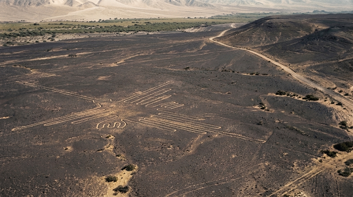
Between approximately 500 BCE and 500 CE, the Nazca people of southern Peru created one of the world's most enigmatic archaeological achievements: vast geoglyphs etched into the desert floor that remain visible today. The Nazca Lines comprise over 800 straight lines extending up to 48 kilometers, 300 geometric shapes, and 70 biomorphic figures including a spider, hummingbird, monkey, and whale. These designs, ranging from 400 meters to several kilometers in length, were created by removing the reddish pebble layer to reveal lighter ground beneath—a technique that has preserved them for two millennia in one of Earth's driest climates.
Despite widespread popular theories involving extraterrestrials and lost ancient technologies, mainstream archaeology has established the Lines as products of human engineering, created without aerial perspective using simple surveying techniques. The true mystery lies not in their construction—which has been successfully replicated using period-appropriate tools—but in their purpose. Academic consensus has evolved from simple astronomical calendar theories toward understanding the Lines as part of a complex ritual landscape tied to water worship, pilgrimage routes, and ceremonial practices in a civilization dependent on scarce water resources.
The geoglyphs face growing threats from climate change, increased tourism, development, and deliberate vandalism. Modern remote-sensing technology continues to reveal previously unknown figures, with over 140 new geoglyphs identified between 2019 and 2020 using AI analysis of satellite imagery. This investigation examines the established archaeological record, credible scientific hypotheses, preservation challenges, and the persistent gap between popular mythology and documented evidence.
Background
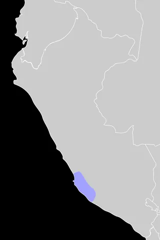
The Nazca culture flourished in the river valleys of southern coastal Peru during the Early Intermediate Period, roughly contemporaneous with the late Roman Republic and early Roman Empire. This pre-Columbian society developed sophisticated irrigation systems, polychrome ceramics, and textile production in an environment characterized by extreme aridity—the Nazca Desert receives less than 4mm of annual rainfall, making it one of the driest places on Earth.
The geoglyphs occupy the Pampa region, a high arid plateau approximately 400 meters above sea level stretching between the Ingenio and Nazca river valleys. The desert floor's unique composition—reddish iron oxide-coated pebbles atop lighter-colored clay and gypsum—created the perfect medium for these designs. Removal of the dark surface layer exposed the lighter subsurface, creating lines that oxidized differently and remained visible across centuries. The extreme aridity, minimal wind erosion, and geological stability of the region have preserved these features with remarkable fidelity.
Local inhabitants were aware of the geoglyphs for centuries, but systematic scientific attention began only in the 1920s. Peruvian archaeologist Toribio Mejía Xesspe conducted the first documented study in 1927 after observing the Lines while hiking through the foothills. The geoglyphs gained international attention in 1939 when American historian Paul Kosok, flying over the desert while investigating ancient irrigation systems, recognized their scale and complexity. Kosok's collaboration with German mathematician Maria Reiche, who dedicated her life to mapping, measuring, and protecting the Lines from 1946 until her death in 1998, established the foundation for modern Nazca studies.
The Investigation
Construction Techniques: From Mystery to Established Fact
Early speculation about the Lines' construction invoked lost technologies, ancient aerial flight, or extraterrestrial assistance. These theories collapsed under rigorous archaeological investigation. ESTABLISHED FACT: The geoglyphs were created by human labor using simple surveying techniques available to the Nazca culture.
Experimental archaeology has demonstrated the construction process. In 1982, archaeologist Joe Nickell successfully replicated a Nazca figure using materials and techniques available to the ancient Nazca people, including wooden stakes, cord, and basic surveying equipment. The process involved:
1. Creating small-scale models 2. Establishing a central point 3. Using rope and stakes to create scaled-up versions 4. Removing surface pebbles by hand to depths of 10-30 cm 5. Placing removed stones along line edges to enhance contrast
Radiocarbon dating of organic material (wood stakes, pottery sherds) found embedded in the geoglyphs consistently dates them to the Nazca period (200 BCE–600 CE), with some lines potentially originating in the earlier Paracas culture (500-200 BCE). The straightness of lines extending for kilometers was achieved through simple line-of-sight surveying using stakes and cord—a technique requiring planning and coordination but no advanced technology.
The Astronomical Hypothesis and Its Limitations
Paul Kosok initially proposed in the 1940s that the Lines functioned as a giant astronomical calendar. Maria Reiche expanded this theory, suggesting specific lines aligned with solstice and equinox positions, serving agricultural and ceremonial timing functions for a society dependent on predictable water flow from Andean snowmelt.
This hypothesis contains elements of truth but significant oversimplification. ESTABLISHED FACT: Some lines do align with astronomically significant positions, including solstice sunrises and sunsets. However, systematic study by archaeoastronomer Anthony Aveni and colleagues in the 1980s-1990s demonstrated that the astronomical alignments occur at rates consistent with random chance given the number of lines present. With over 800 linear features pointing in diverse directions across a flat plain, some astronomical alignments are statistically inevitable.
Aveni's team used precise surveying equipment to map line orientations and compare them against significant astronomical positions. Published results showed that while certain lines do align with celestial events, the overall pattern does not support a primary astronomical function. The hypothesis that the entire system functioned as an astronomical observatory or calendar is not supported by the statistical evidence. INFERENCE: Astronomical considerations may have influenced the placement of specific lines as part of a broader ritual system, but astronomy was not the primary organizing principle.
Water Ritual and Ceremonial Landscape Theory
Contemporary archaeological consensus, developed through the work of researchers including Johan Reinhard, David Johnson, Persis Clarkson, and Anthony Aveni, positions the Lines within a ritual landscape centered on water worship and mountain deity veneration—understandable priorities for a civilization in one of Earth's driest regions.
ESTABLISHED FACTS supporting this interpretation:
- Many lines point toward water sources, rivers, and mountains where water originated - Nazca ceramics and textiles prominently feature water-related imagery and deities - Archaeological evidence shows ceremonial offerings (Spondylus shells, pottery) placed at line intersections and termini - Ray-center designs (focal points where multiple lines converge) are associated with nearby huacas (sacred sites) - The distribution of geoglyphs correlates with ancient foot traffic patterns and ceremonial pathways
The ritual landscape theory proposes that the Lines functioned as processional routes for ceremonial activities, possibly including group walking or running during religious festivals. The biomorphic figures—visible primarily from elevated positions on nearby hills—may have served as pilgrimage destinations or ritual focal points. The geometric designs and long straight lines could represent pathways for ceremonial movement, connecting sacred sites and water sources across the landscape.
This interpretation aligns with broader Andean religious practices documented ethnographically and archaeologically, including ceque systems (radial line systems connecting sacred sites around Cusco in the later Inca period) and the importance of mountain worship related to water provision. STRONG INFERENCE: The Lines represented a sacred geography mapping the relationship between people, water, and the divine in Nazca cosmology.
The Extraterrestrial Hypothesis: Popular Fiction vs. Archaeological Evidence
No investigation of the Nazca Lines can ignore the popularization of extraterrestrial theories, primarily through Erich von Däniken's 1968 book "Chariots of the Gods?" Von Däniken proposed that the Lines served as landing strips or signals for alien spacecraft, arguing that ancient peoples lacked the capability or motivation to create such designs without extraterrestrial instruction.
ESTABLISHED FACTS conclusively refute this hypothesis:
- The Lines' surface characteristics (shallow grooves 10-30cm deep with loose stones) make them completely unsuitable as aircraft landing strips of any kind - Experimental archaeology has demonstrated construction using documented Nazca-period tools and techniques - Radiocarbon dating consistently places the Lines in the documented Nazca cultural period - The designs fit within established patterns of Andean religious iconography, appearing on contemporary Nazca ceramics and textiles - No physical evidence (artifacts, materials, or structures) suggests extraterrestrial involvement - The designs are consistent with the technological capabilities, artistic traditions, and religious practices of the Nazca culture
The extraterrestrial hypothesis persists in popular culture despite complete lack of supporting evidence. It represents a form of archaeological pseudoscience that professional archaeologists classify alongside other fringe theories that attribute ancient achievements to external agents rather than human ingenuity. The persistence of such theories has been analyzed by scholars of pseudoarchaeology as reflecting both Western cultural biases that underestimate indigenous capabilities and the entertainment industry's preference for sensational narratives over documented evidence.
Modern Discoveries: Remote Sensing and AI Analysis
While the major geoglyphs have been catalogued since the mid-20th century, technological advances continue revealing new features. Between 2004 and 2020, Japanese researchers from Yamagata University, led by Masato Sakai, discovered over 140 new geoglyphs using a combination of on-the-ground surveys, high-resolution satellite imagery, and artificial intelligence analysis.
The AI-based discovery method, reported in 2019-2020, used machine learning algorithms trained to recognize geoglyph patterns in satellite and drone imagery. This technology identified figures invisible or barely visible from ground level, including smaller biomorphs (often humanoid figures) averaging 2-6 meters in size—substantially smaller than the famous large-scale animal figures.
ESTABLISHED FACT: These newly discovered geoglyphs predominantly date to the earlier Paracas period (500-200 BCE), predating most of the large Nazca figures. They represent different stylistic traditions, with the smaller Paracas figures typically depicting humans and heads, while later Nazca geoglyphs favor animals and plants. This discovery pushed back the timeline of geoglyph creation and revealed a longer, more complex tradition than previously documented.
The application of remote sensing technology raises the possibility that additional undiscovered features remain, particularly smaller or degraded designs difficult to detect with traditional survey methods.
Preservation Challenges and Vandalism
The same environmental conditions that preserved the Lines for two millennia now face disruption from human activity and climate change. The Nazca Lines have suffered documented damage from multiple sources:
Tourism and Development
Despite UNESCO protection since 1994 and Peruvian national monument status since 1969, the Lines have experienced damage from off-road vehicles, illegal construction, and tourism infrastructure. In 2014, Greenpeace activists entered a restricted area during a publicity stunt, leaving visible footprints near the hummingbird figure—damage that made international headlines and resulted in criminal charges.
Agricultural Expansion
Increased agricultural development around the protected zone has encroached on less-prominent geoglyphs outside the core tourist areas.
Vehicle Traffic
Tire tracks from vehicles crossing the desert have damaged or destroyed portions of multiple geoglyphs. In 2018, a truck driver was arrested after creating deep tracks across multiple lines.
Climate Change
While the extreme aridity has preserved the Lines, climate modeling suggests potential increases in rainfall intensity and wind erosion that could accelerate degradation. Flooding events, though rare, have caused documented damage.
Deliberate Vandalism
Beyond accidents and negligence, some damage has been intentional, including graffiti and unauthorized alterations.
Peru has increased enforcement and protection efforts, including drone surveillance, increased ranger presence, and severe penalties for unauthorized access. However, the scale of the protected area (over 450 km²) and limited resources make comprehensive protection challenging. The Peruvian government works with international organizations, including UNESCO and Japan's Cultural Heritage Preservation Office, on monitoring and conservation strategies.
Alternative and Fringe Theories
Beyond the extraterrestrial hypothesis, various alternative theories have been proposed:
Textile Pattern Theory
Some researchers suggest connections between geoglyph designs and patterns found in Nazca textiles, proposing that the Lines represent enlarged versions of fabric motifs with religious or cultural significance. MODERATE EVIDENCE supports stylistic connections between geoglyphs and textile patterns, though this observation does not explain the Lines' purpose independently.
Hot Air Balloon Theory
Proposed by Jim Woodman in 1975, this theory suggests the Nazca people possessed hot air balloon technology, explaining their ability to design figures best viewed from altitude. Woodman constructed a balloon using materials available to the Nazca and achieved brief flight. However, WEAK EVIDENCE supports actual historical use: no archaeological evidence of balloons exists, and experimental archaeology has demonstrated that ground-level surveying techniques adequately explain geoglyph construction without requiring aerial perspective.
Running Track Theory
Proposed by anthropologist Anthony Aveni among others, suggesting some lines served as ritual running paths or pilgrimage routes. This theory has STRONG SUPPORTING EVIDENCE including: worn areas at line termini consistent with repeated foot traffic, ethnographic parallels in Andean pilgrimage traditions, and alignment patterns connecting ceremonial sites.
Evidence Assessment
Established Facts
Construction by Nazca Culture (500 BCE–500 CE)
Radiocarbon dating of organic materials, ceramic analysis, and stylistic consistency with documented Nazca culture definitively establish human construction during this period. Experimental archaeology has replicated construction techniques using period-appropriate tools.
Creation Method
Surface removal technique exposing lighter subsurface has been observed, documented, and replicated. The process requires no advanced technology.
Scale and Composition
Over 800 lines, 300 geometric figures, and 70+ biomorphic designs across approximately 450 km² have been surveyed and catalogued using GPS and aerial photography.
Environmental Preservation
Extreme aridity (less than 4mm annual rainfall), minimal wind, geological stability, and iron oxide oxidation differences have preserved features for 2,000+ years through natural processes.
UNESCO Protection
World Heritage Site designation since 1994 is documented and enforced (with varying effectiveness).
Recent Discoveries
Japanese research teams documented discovery of 140+ new geoglyphs between 2004-2020 using remote sensing and AI, published in peer-reviewed archaeological journals.
Strong Evidence
Water Ritual and Ceremonial Landscape Function
Multiple independent lines of evidence support ritual/ceremonial purposes tied to water worship: alignment with water sources and mountains, ceremonial offerings at line intersections, correlation with foot traffic patterns, ethnographic parallels in Andean religious practices, and iconographic consistency with Nazca religious art. Published research by Reinhard, Aveni, Clarkson, and others provides converging support.
Multi-Period Construction
Stratigraphic analysis, stylistic evolution, and radiocarbon dating demonstrate geoglyph creation spanning multiple cultural periods (Paracas through Nazca), with stylistic and size differences between earlier and later features. This timeline is supported by Japanese survey work and multiple dating studies.
Ritual Walking/Pilgrimage Routes
Archaeological evidence of worn areas, ceramic offerings, and spatial analysis of line patterns supporting ritual movement along geoglyphs, documented in peer-reviewed studies.
Moderate Evidence
Limited Astronomical Alignment
Some lines do align with solstice and equinox positions, documented through precise surveying. However, statistical analysis by Aveni demonstrates that the number of alignments is consistent with chance given the number of lines. Astronomical considerations may have influenced specific features without being the system's primary purpose—a nuanced position supported but not definitively proven.
Connection to Textile Patterns
Stylistic similarities exist between geoglyph designs and Nazca textile motifs, suggesting shared symbolic vocabulary. The nature and direction of this relationship requires further research.
Geoglyphs as Cultural Identity Markers
Some researchers propose that different geoglyph types were created by different social groups within Nazca society to mark territory or identity. Survey data shows some spatial clustering by design type, but the evidence remains suggestive rather than conclusive.
Weak Evidence
Hot Air Balloon Technology
While Woodman demonstrated that materials available to the Nazca could theoretically construct a primitive balloon, no archaeological evidence of actual balloon use exists. Ground-level construction techniques adequately explain geoglyph creation without requiring aerial perspective. This theory has not gained acceptance in mainstream archaeology.
Specific Calendar Function
While general calendrical or astronomical awareness may have been incorporated, the hypothesis that the Lines functioned as a precision astronomical calendar for agricultural timing is not supported by statistical analysis of alignments.
Disputed Claims
Precise Purpose of Individual Figures
While the general ceremonial/ritual landscape interpretation has strong support, the specific meaning or function of individual biomorphic figures remains debated among archaeologists. Interpretations linking specific figures to constellations, water deities, or shamanic transformation vary by researcher without definitive evidence.
Social Organization of Construction
Whether geoglyph construction represented community-wide efforts, specialized labor groups, or elite-directed projects remains unclear. The organizational structure behind this massive investment of labor is inferred from general Nazca social patterns rather than direct evidence from the Lines themselves.
Unsupported Claims
Extraterrestrial Creation or Guidance
No physical, archaeological, or documentary evidence supports alien involvement. This hypothesis is rejected by the entire professional archaeological community and contradicts all established evidence about Nazca capabilities, cultural context, and construction methods.
Landing Strips for Aircraft
The Lines' physical characteristics (shallow grooves with loose stones) make them unsuitable as landing surfaces. This claim reflects misunderstanding of both the Lines' structure and basic aviation requirements.
Lost Advanced Technology
Claims that the Lines required lost ancient technologies (laser cutting, advanced mathematics, aerial imaging) are contradicted by experimental archaeology demonstrating construction with documented Nazca-period tools and techniques.
Credible Dissenting Voices
Within mainstream archaeology, genuine scholarly debate focuses on interpretation rather than basic facts:
Dr. Anthony Aveni (Colgate University, archaeoastronomer): While supporting the ceremonial landscape interpretation, Aveni emphasizes caution about over-interpreting specific alignments or purposes. His statistical work challenged earlier astronomical theories, but he acknowledges some astronomical awareness likely influenced placement of certain features. His dissent is methodological—favoring evidence-based claims over interpretive speculation.
Dr. Persis Clarkson (University of Winnipeg): Emphasizes the Lines as part of broader Nazca landscape modification including geoglyphs, ceremonial centers, and settlements that should be understood as an integrated system. She dissents from interpretations that treat the Lines in isolation from broader Nazca society and landscape use.
Dr. Masato Sakai (Yamagata University): Leading the Japanese research team, Sakai has documented stylistic and chronological differences between Paracas and Nazca geoglyphs. He suggests earlier geoglyphs may have served different functions than later ones, dissenting from interpretations that treat all geoglyphs as a unified system with a single purpose.
These scholarly disagreements involve interpretation of purpose and meaning within established archaeological frameworks. No credentialed archaeologists support extraterrestrial theories or reject the fundamental archaeological evidence establishing human construction during documented cultural periods.
Legacy
Contemporary Significance
The Nazca Lines stand as testament to pre-Columbian achievement in landscape engineering, astronomical observation, and cultural expression. They represent one of the world's largest and most ambitious artistic undertakings, created through sustained communal effort over centuries. For Peru, they constitute a major cultural heritage site and tourism destination, attracting over 100,000 visitors annually and contributing significantly to regional economy.
The Lines continue driving archaeological research on Andean prehistory, pre-Columbian religion, and ancient engineering. Remote sensing technology development for geoglyph detection has applications in broader archaeological survey work globally. The ongoing AI-assisted discovery of new features demonstrates how technological advances enable new insights into long-studied sites.
Persistent Misunderstandings
Despite decades of archaeological research, several misconceptions persist in popular understanding:
Misconception
The Lines are visible only from aircraft and therefore require ancient flight or extraterrestrial explanation.
Reality
While full appreciation of large figures requires elevation, the Lines are visible from surrounding hills where the Nazca people could observe them. Ground-level construction using surveying techniques has been experimentally demonstrated. As archaeologist Joe Nickell stated: "The mystery isn't how they were made, but why."
Misconception
The Lines are deeply mysterious with no credible explanation.
Reality
Scientific consensus understands the Lines as part of a ceremonial landscape related to water worship and ritual activities, supported by multiple independent evidence lines. The specific meanings of individual figures remain debated, but the general purpose and cultural context are well-established.
Misconception
Ancient peoples lacked the capability or motivation to create such features.
Reality
This assumption reflects cultural bias rather than archaeological evidence. Many cultures invested enormous labor in religious monuments and ceremonial landscapes. The Nazca Lines represent a different expression of the same human impulse seen in pyramids, cathedrals, and other monumental religious architecture.
Important Scholarly Perspectives
"The Nazca Lines are essentially a sacred landscape where ancient ritual pathways and ceremonial structures overlay a desert canvas. They represent the largest piece of religious art ever created." — Dr. Anthony Aveni, archaeoastronomer and Lines researcher
"What we're looking at is not a single unified system but rather an evolving tradition of landscape marking that spanned centuries and possibly served different purposes at different times." — Dr. Persis Clarkson, archaeologist
"The discovery of over 140 new geoglyphs using AI demonstrates that even well-studied archaeological sites can yield new information when approached with new methods." — Dr. Masato Sakai, Yamagata University
Research Leads and Future Potential
Several areas remain open for productive research:
Remote Sensing Expansion
If AI analysis revealed 140+ previously unknown geoglyphs in recent surveys, systematic application of these techniques across the entire Nazca region could discover additional features, particularly smaller or degraded designs.
Climate and Preservation Modeling
Understanding how projected climate changes might affect preservation would inform protection strategies. Systematic monitoring of degradation rates under current conditions provides baseline data.
Archaeological Context
Excavation of ray-center nodes and line termini where ceremonial offerings concentrate could reveal additional information about ritual practices and chronology. Most archaeological attention has focused on the Lines themselves rather than associated features.
Comparative Analysis
Systematic comparison with other Andean geoglyph traditions (found in Chile and elsewhere) could illuminate broader regional patterns in landscape modification and ceremonial practice.
Paracas-Nazca Transition
Recent discoveries of earlier Paracas geoglyphs raise questions about cultural continuity and change. Understanding the relationship between earlier and later geoglyph traditions could reveal important information about cultural development.
Ethnographic Parallels
Detailed comparison with documented Andean ceremonial practices, particularly those involving landscape-scale ritual movement and water worship, could provide interpretive frameworks grounded in cultural continuity.
Confidence Assessment
The archaeological documentation of the Nazca Lines is robust regarding construction methods, dating, and general cultural context—these aspects rate very high confidence based on decades of systematic research, experimental archaeology, and multiple independent lines of evidence. The transition from mystery about construction capability to established understanding of technique represents successful resolution through scientific investigation.
Confidence regarding specific purposes and meanings is moderate to strong for the general ceremonial/ritual landscape interpretation, supported by converging evidence from multiple sources. However, the specific meanings of individual figures and the precise nature of ceremonies conducted along the lines remain areas of interpretation rather than established fact. The archaeological record provides strong context for general function but limited evidence about specific ritual details.
The greatest uncertainty involves aspects of social organization: who made construction decisions, how labor was organized, whether different groups created different types of geoglyphs, and how the system evolved over the centuries of its use. These questions remain open because the physical evidence of the Lines themselves provides limited information about the social processes behind their creation.
Overall, the Nazca Lines represent a case where the physical evidence is well-documented and preserved, construction techniques are understood, general cultural context is established, but interpretive questions about specific meanings and social practices remain productively debated within mainstream archaeology. The persistence of fringe theories in popular culture reflects the entertainment value of speculation rather than genuine archaeological uncertainty—the core facts are not in serious dispute among qualified researchers.
Case Timeline
- 500 BCEACADEMICParacas culture begins creating earliest geoglyphs in the regionRecent discoveries by Japanese researchers identified smaller humanoid figures predating classic Nazca designs
- 200 BCECORROBORATEDNazca culture emerges, continuing and expanding geoglyph traditionStylistic shift toward larger animal and plant figures; cultural transition documented archaeologically
- 1 CE–500 CEPRIMARY SOURCEPeak period of geoglyph creation including most famous large-scale figuresRadiocarbon dating places majority of major geoglyphs in this period during Nazca cultural florescence
- 1553CORROBORATEDSpanish conquistador Pedro Cieza de León documents observations of markingsEarliest European written reference, though significance not recognized; local knowledge continued unbroken
- 1927ACADEMICToribio Mejía Xesspe conducts first systematic archaeological studyPeruvian archaeologist initiates scientific investigation, recognizing geoglyphs as archaeological features
- 1939CORROBORATEDPaul Kosok's aerial reconnaissance brings international attentionAmerican historian's flights reveal scale and complexity, sparking systematic research programs
- 1946CORROBORATEDMaria Reiche begins lifelong dedication to mapping and protecting the LinesGerman mathematician's work establishes comprehensive surveys and advocates for preservation; continues until her death in 1998
- 1968CREDIBLE REPORTINGErich von Däniken publishes 'Chariots of the Gods?' proposing extraterrestrial theoriesBestselling book popularizes alien hypothesis rejected by archaeologists; creates enduring popular mythology
- 1969GOVERNMENT RECORDPeru designates Nazca Lines as protected national cultural heritageNational monument status provides legal protection framework; enforcement challenges persist
- 1982ACADEMICJoe Nickell successfully replicates Nazca figure using period-appropriate toolsExperimental archaeology demonstrates construction feasibility without advanced technology, refuting mystery claims
- 1980s-1990sACADEMICAnthony Aveni conducts systematic astronomical alignment studiesStatistical analysis challenges astronomical calendar hypothesis; establishes ceremonial landscape interpretation
- 1994GOVERNMENT RECORDUNESCO designates Nazca Lines as World Heritage SiteInternational recognition and protection status; triggers increased tourism and preservation concerns
- 2004ACADEMICYamagata University begins systematic Japanese survey projectMulti-year research program using advanced surveying and remote sensing technology
- 2014CREDIBLE REPORTINGGreenpeace activists damage site during unauthorized publicity stuntInternational incident highlights vulnerability; results in criminal charges and increased security measures
- 2018CREDIBLE REPORTINGTruck driver arrested after creating tire tracks across multiple geoglyphsOngoing vehicular damage demonstrates enforcement challenges despite protection status
- 2019-2020ACADEMICAI analysis reveals 140+ previously unknown geoglyphsMachine learning applied to satellite imagery identifies smaller, older Paracas-period figures; published in peer-reviewed journals
- 2020sACADEMICClimate change projections indicate increasing threats to preservationScientific modeling suggests potential for increased erosion and extreme weather events affecting long-term survival
- 2023-PresentCREDIBLE REPORTINGOngoing remote sensing surveys and preservation monitoringInternational collaboration continues documentation and protection efforts; drone surveillance expanded
Key People
Organizations
Evidence Library
- physicalPHYS-A1The Geoglyphs Themselves (Over 800 Linear Features, 300+ Geometric Designs, 70+ Biomorphs)
The primary physical evidence: figures created by removing 10-30cm of reddish surface pebbles to expose lighter subsurface. Excellent preservation due to extreme aridity. Documented through GPS surveys, aerial photography, and satellite imagery. Represents highest-tier established fact.
- dataDATA-A2Radiocarbon Dating Results from Multiple Studies (1960s-2010s)
Organic materials (wood stakes, ceramic fragments, plant material) found at geoglyph sites consistently date to 500 BCE–500 CE range, confirming Nazca-period construction. Published in peer-reviewed archaeological literature. Establishes construction timeline definitively.
- dataDATA-B1Aveni Statistical Analysis of Astronomical Alignments (1980s)
Systematic surveying and statistical analysis of line orientations versus astronomical positions. Demonstrated that alignments occur at rates consistent with random chance. Published in peer-reviewed journals; challenges astronomical calendar hypothesis.
- documentDOC-A3Yamagata University AI Discovery Publications (2019-2020)
Peer-reviewed papers documenting machine-learning-assisted identification of 140+ new geoglyphs, primarily smaller Paracas-period figures. Includes methodology, coordinates, and chronological analysis demonstrating earlier tradition than previously documented.
- physicalPHYS-B2Ceramic Offerings at Line Intersections and Ray Centers
Archaeological excavations have recovered Nazca ceramics and Spondylus shells (imported from coastal Ecuador) at geoglyph nodes. Indicates ceremonial use and water-related ritual (Spondylus associated with water deities in Andean religion). Strong supporting evidence for ritual landscape interpretation.
- dataDATA-A4Experimental Archaeology Replication Studies (Nickell 1982, Others)
Documented successful recreation of geoglyph figures using only tools and techniques available to Nazca culture. Published methodology demonstrates construction feasibility without advanced technology; includes time-labor calculations.
- photoPHOTO-A51940s-1950s Aerial Photographs by Paul Kosok and Maria Reiche
Historical aerial photography documentation establishing baseline condition. Enables comparison with modern satellite imagery to assess degradation. Archived in multiple institutions; represents primary documentation of mid-20th century preservation state.
- documentDOC-A6UNESCO World Heritage Site Designation Documents (1994)
Official international recognition and protection framework. Includes site evaluation, significance assessment, and conservation recommendations. Establishes legal protection status and ongoing monitoring requirements.
Evidence Gallery


Sources
Trace the trail yourself
Investigation Network
Live Discussion
0 Perspectives
Add to the record. Be specific. Cite where you can.
If you're learning about this topic for the first time, these are the best places to continue — documented evidence and historical relationships are the guide.
Named in “The Nazca Lines”.
Read more dossiers like this
Get a quiet one-line bulletin when new investigative files are published. Bound to this dossier — useful for tracking follow-ups.